North-South Segment 1 Tier 2 Environmental Impact Statement (EIS) and Design Concept Report (DCR), US 60 to Arizona Farms Road (State Route 505)
Welcome
The Arizona Department of Transportation (ADOT) is preparing a Tier 2 Environmental Impact Statement (EIS) and Design Concept Report (DCR) for the North-South Corridor Segment 1, from US 60 to Arizona Farms Road (State Route 505).
With the Notice of Intent now published, the study team has formally initiated the EIS and DCR process. The study will continue to evaluate alternative alignments for Segment 1 of the corridor, initial interchange design concepts, other key design features, and potential environmental impacts and mitigation measures.
Learn more about the study process by reviewing our self-guided, online presentation and materials!
The environmental review, consultation and other actions required by applicable Federal environmental laws for this project are being or have been carried out by ADOT pursuant to 23 USC 327 and a Memorandum of Understanding dated 06/25/24 and executed by FHWA and ADOT
Study Overview
Study Area
The Segment 1 Study area extends from US 60 to Arizona Farms Road and makes up approximately 20 miles of the full North-South corridor.
ADOT will also be preparing a separate Tier 2 study for the segment of the North-South corridor between Arizona Farms Road and I-10 near Eloy.
Study Goals
The current phase of the study is actively reviewing public comments submitted during the recent comment period, while considering environmental and engineering constraints in order to:
- Refine the purpose and need of the proposed project
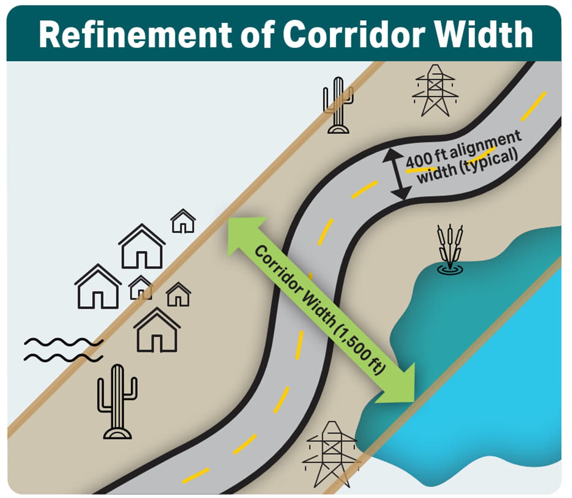
- Revise the preliminary range of alternatives for potential 400-foot-wide freeway alignments within the 1,500-foot Tier 1 corridor selected in 2021
- Identify potential interchange locations and advancing initial interchange design concepts
Ultimately the study will:
- Identify potential interchange locations and develop interchange design concepts
- Develop and circulate for public review and comment a draft Tier 2 EIS and DCR that identifies the Preferred Build Alternative, which will be compared against the No Build, or do nothing alternative
- Prepare a final EIS and DCR document identifying the Selected Alternative
Project Purpose and Need
The North-South Corridor Study — Tier 1 EIS and DCR identified the following purpose and need for the North-South corridor.
A continuous, controlled-access north-to-south transportation corridor would:
- Improve access to future activity centers
- Improve regional mobility
- Improve north-to-south connectivity
- Integrate the region's transportation network
- Address existing and future population and employment growth
A refined needs assessment specific to Segment 1 is available for review in the Preliminary Purpose and Need. Comments on the Preliminary Purpose and Need are welcomed during the comment period.
Study Map
Click here to view the interactive map of the North-South corridor.
Study Process & Schedule
- The Federal Highway Administration (FHWA), on behalf of ADOT, published a NOI in May 2025 to prepare a Tier 2 EIS and DCR, which formally initiated the NEPA process
- During the current Alternative Development and Evaluation phase, a series of public information meetings were held in which ADOT received input from the public, agencies, and tribal governments on the preliminary range of highway alignment alternatives, the study’s purpose and need, and other relevant information to inform development of the Tier 2 Draft EIS
- As the study progresses, ADOT will evaluate various build alternatives and ultimately identify a Preferred Alternative based on engineering and environmental considerations, as well as agency, tribal government and public input. This information, when available, will be circulated for public review and comment in a draft Tier 2 EIS and DCR that compares the build alternatives against the No Build, or do nothing alternative, and identifies a Preferred Alternative. ADOT will hold public hearings to receive comments on the Draft EIS/Initial DCR and will provide other comment methods. At the conclusion of the study, ADOT anticipates the release of a Final EIS and DCR document addressing comments on the Draft EIS and will issue a Record of Decision (ROD) identifying a Selected Alternative. Funding must be identified to issue a ROD for the North-South Segment 1 EIS process, and to move forward with the project design and/or right-of-way acquisition if a Build Alternative is selected
- There is no timeline to construct the North-South corridor, since it is not currently funded for design or construction
*Schedule subject to change.
Constraints & Results
Constraint Evaluation Process
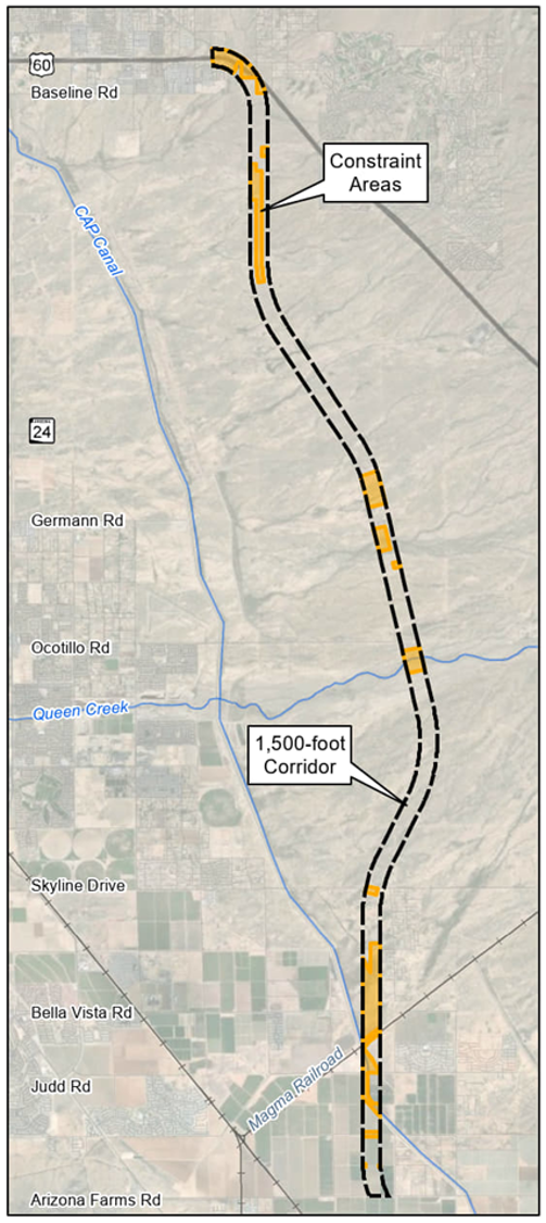
ADOT conducted a constraint evaluation process to identify the preliminary range of alternatives. This process started with collecting data and mapping the environmental and engineering constraints within the 1,500-foot-wide Segment 1 corridor. This constraint mapping process resulted in the identification of constraint and opportunity areas, which provide the basis for developing the preliminary alignment build alternatives.
Map Constraints within Study Corridor
Cultural Resources
- Section 4(f)
- Clean Water Act/Section 404
- Hazardous Materials
- Biological Resources
- Wildlife Habitat and Connectivity
- Prime and Unique Farmland
- Social and Economic Considerations
- Noise
- Drainage and Floodplains
- Major Utilities
- Terrain
- Existing Infrastructure and Feature Crossings (CAP Canal, Magma Arizona Railroad)
- Agency, tribal government, Stakeholder and Public Input
Constraint Mapping Results
Based on the data collected, ADOT identified constraint areas within the 1,500-foot Segment 1 North-South Corridor from US 60 to Arizona Farms Road. The constraint areas are identified on the map to the right and represent areas where various environmental resources and engineering/technical constraints are present and should be avoided when identifying potential highway alignment alternatives.
Constraint Mapping Results

Within the northernmost 4.5 miles of the study corridor between US 60 and Williams Field Road, some of the constraints include federal land withdrawn for the Bureau of Reclamation, SRP power transmission lines, residential homes and other sensitive environmental resource areas.

Between Williams Field Road and Roberts Road, we identified minimal constraint areas affecting potential alignment alternatives. Within the Queen Creek portion of the corridor, we identified several overlapping constraints, including a hazardous materials site potentially requiring mitigation, a moderate-quality Monarch butterfly habitat, a potential wildlife crossing location, special flood hazard areas and jurisdictional Waters of the U.S, requiring minimization and mitigation, biological, and other sensitive environmental resources. The entirety of the land within this portion of the Segment 1 Corridor is State Trust land and is currently vacant and undeveloped.

In the southernmost four miles of the Segment 1 Corridor between Roberts Road and Arizona Farms Road, there are multiple constraints identified. Constraints include existing residences both within and east of the Segment 1 Corridor, planned development, the Central Arizona Project canal, Reclamation lands northeast of the canal, a railroad corridor and a burrowing owl relocation site.
Preliminary Range of Alternatives
Overview
ADOT has developed a preliminary range of alternatives for an approximately 400-foot-wide highway alignment within the 1,500-foot North-South Corridor study area.
- At this current study phase, preliminary build alternatives are identified as a line in the center of the approximately 400-foot highway alignment
- These preliminary alignments were developed to preliminarily avoid and minimize potential impacts to different resources where possible
- Alternatives being considered include the Preliminary No Build Alternative, which consists of future conditions in 2050 without implementation of a new north-south highway (State Route 505)
Preliminary Alignments: US 60 to Roberts Road
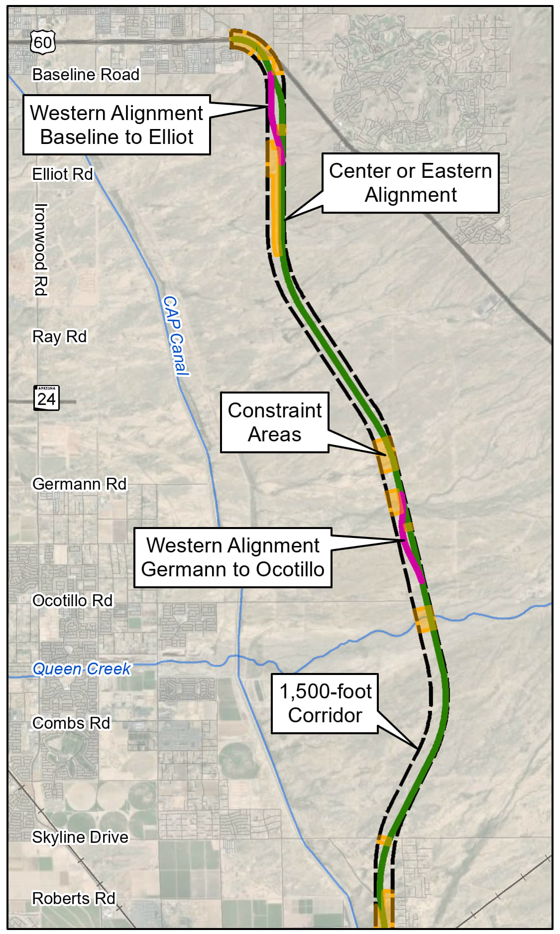
In the northernmost 16 miles of the Segment 1 Corridor between US 60 and Roberts Road, ADOT has identified a preliminary alignment that generally stays within the center and eastern zones of the study corridor (shown in green on the map), with two alignment alternatives in two areas to avoid constraints:
- Baseline Road and Elliot Road: Western alignment (shown in pink) or the eastern alignment (shown in green); and,
- Germann Road to Ocotillo Road: Western alignment (shown in pink) or eastern alignment (shown in green)
Preliminary Alignments: Roberts Road to Arizona Farms Road
In the southernmost four miles of the 1,500-foot-corridor between Roberts Road and Arizona Farms Road, ADOT has identified three preliminary alignment alternatives in the western, center and eastern portions of the 1,500-foot corridor.
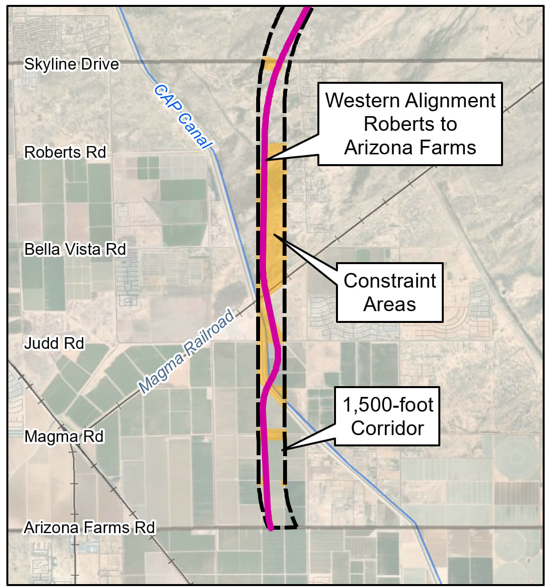
The western alternative shown in pink in the left graphic is the closest to the Sonoqui Dike. Compared with the center and eastern alignments, the western alignment would require the largest overlap with the Bureau of Reclamation (Reclamation) lands east of the canal that provide flood storage and wildlife habitat. This alignment minimizes overlap with planned development near Judd Road. Between Bella Vista Road and Judd Road, the alignment shifts east to cross the CAP Canal that is close to perpendicular.
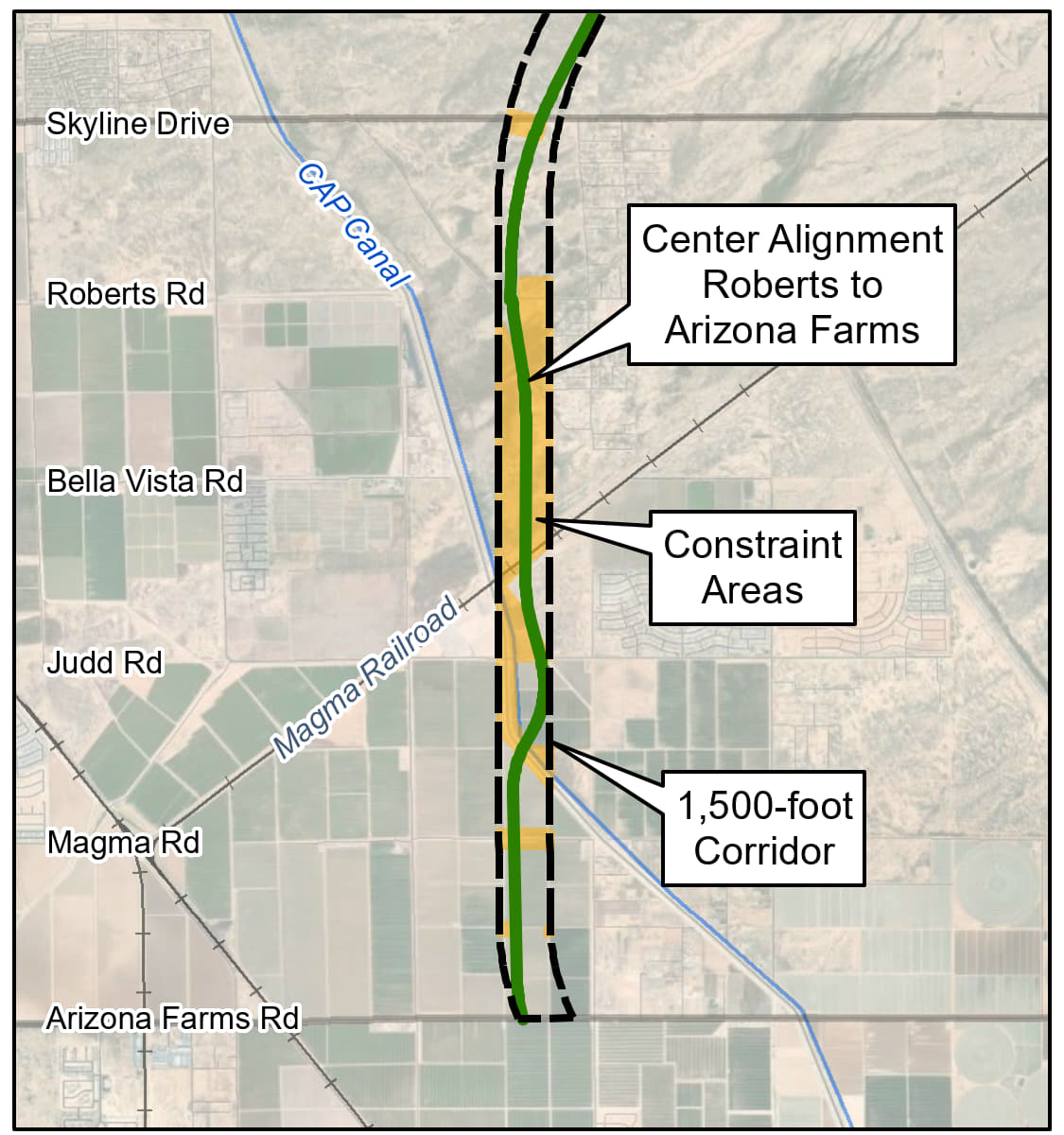
The center alternative shown in green in the middle graphic uses the center zone through the Reclamation lands east of the canal and is slightly farther away from the Sonoqui Dike compared to the west alternative but closer to planned development near Judd Road.
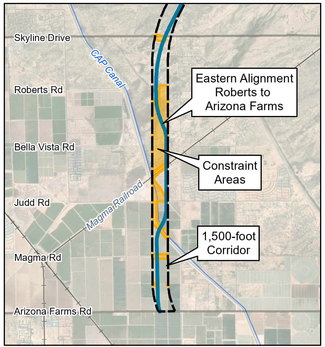
The eastern alternative shown in blue in the right graphic shifts to the eastern portion of the 1,500-foot corridor between Roberts Road and Arizona Farms Road. The eastern alignment is the farthest away from the Sonoqui Dike and would require the smallest amount of overlap with Reclamation lands east of the canal. However, the eastern alignment is closest to planned development north of Judd Road.
Preliminary End-to-End Build Alternatives
- Three preliminary end-to-end approximately 400-foot-wide highway alignment alternatives were developed by combining pieces of the preliminary alignments for each segment of the corridor study area
- These alternatives may be refined following comments on the preliminary alternatives being considered
- As the alternatives evaluation process for the EIS and DCR continues, ADOT may recommend a different combination of the preliminary alignments in a hybrid alternative that is different from the preliminary end-to-end alternatives

Preliminary Alternative 1, shown in pink, combines the western alignment alternatives through constrained areas with the single eastern or center alignment through the remaining portions of the corridor.
Preliminary Alternative 2, shown in green, combines the center alignment alternative between Roberts Road and Magma Road, the eastern alignment alternative through other constrained areas, and the single eastern or center alignment through remaining portions of the corridor.
Preliminary Alternative 3, shown in blue, combines the eastern alignment alternative through constrained areas with the single eastern or center alignment through the remaining portions of the corridor.
Connection to US 60 & Interchange Locations
Connection to US 60
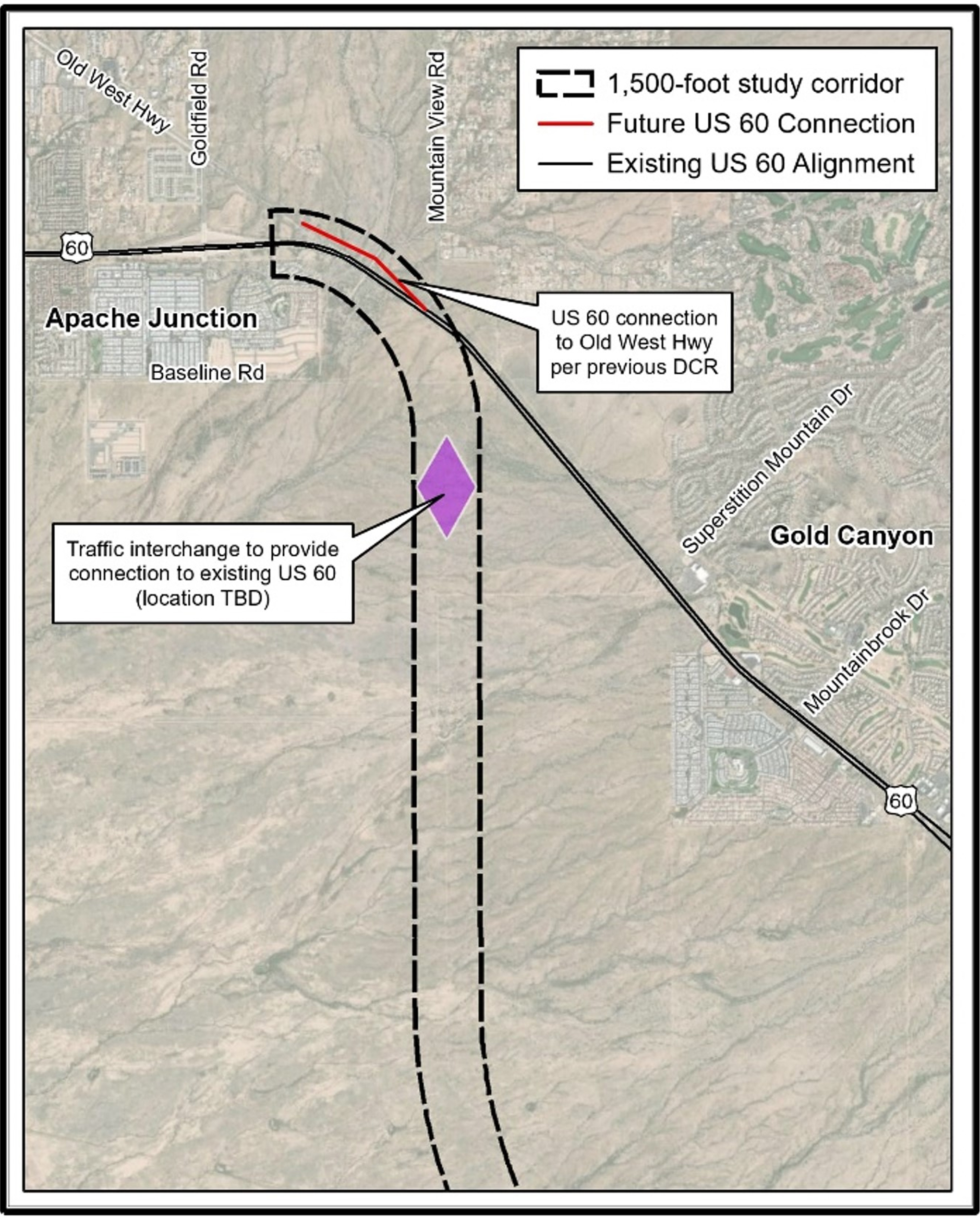
The following is the preliminary concept being considered for the connection between US 60 and the North-South Corridor (State Route 505). These recommendations are consistent with the previous US 60 Alignment Study, Superstition Freeway to Florence Junction (2012):
- The new State Route 505 highway would connect directly from/to US 60
- The existing US 60 east of Mountain View Road would remain (with access points and traffic signals); however, there would no longer be direct access to US 60 to and from the west in this location
- A new traffic interchange on SR 505 near Houston Avenue with a new roadway connection to the east would provide a connection to existing US 60 (to the east)
- The existing US 60 west of Mountain View Road would be slightly realigned to the north and connected to Old West Highway at Goldfield Road
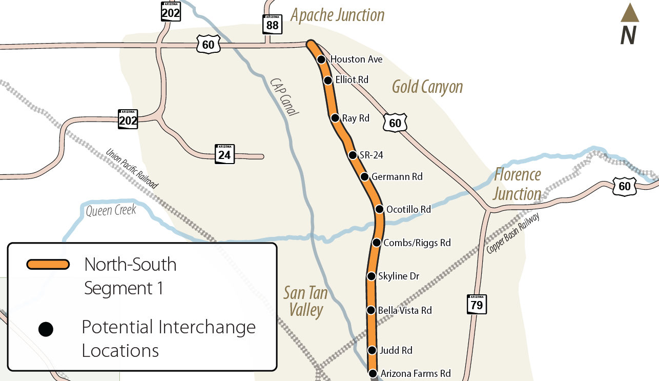
Potential Traffic Interchanges
- Previous Tier 1 EIS identified potential interchange locations
-
The following preliminary interchange locations will be
refined for further study in Tier 2 EIS:
- Houston Avenue
- Elliott Road
- Ray Road
- Future planned State Route 24
- Germann Road
- Ocotillo Road
- Combs Road/Riggs Road
- Skyline Drive
- Bella Vista Road
- Judd Road
- Arizona Farms Road
Resources
Public Meeting Materials
Public Involvement Summaries
Display Boards
Fact Sheet
Presentation
Frequently Asked Questions
Roll Plot
Get Involved
Thank you for your interest in the North-South Corridor Segment 1 Study. The comment period for the current phase of the study was open from April 25 to June 10, 2025. As the study moves forward, ADOT will prepare a Draft Tier 2 EIS and an Initial DCR. The next opportunity for public input will be during the public hearing comment period, which will be announced at a later date."